Webinar Series

Filtering by: Webinar Series

2024 Student Research Symposium-Day 2
Mar
8
3:00 PM15:00

2024 Student Research Symposium-Day 2

Student Research Symposium-Day 2  

Event from 3:30-5 pm


WHAT IS IT?: Student Research Symposium to provide a dedicated space to highlight student’s research

WHY SHOULD YOU ATTEND?:  This is an excellent way for sharing ideas, networking, and having fun

WHO IS INVITED?  

  • Students (undergraduate or graduate) interested in presenting ongoing or completed research related to sedimentology and stratigraphy.  

  • Professionals interested in engaging & providing feedback and support to students.

WHEN/WHERE IS IT?: March 8th, 2024 3:30-5 pm. Please register to receive access.


Click the Dunes to Register Now!

Free to attend

Email questions to information@rmssepm.org

View Event →
2024 Student Research Symposium
Mar
6
3:00 PM15:00

2024 Student Research Symposium

Student Research Symposium-Day 1


Event from 3:30-5 pm


WHAT IS IT?: Student Research Symposium to provide a dedicated space to highlight student’s research

WHY SHOULD YOU ATTEND?:  This is an excellent way for sharing ideas, networking, and having fun

WHO IS INVITED?  

  • Students (undergraduate or graduate) interested in presenting ongoing or completed research related to sedimentology and stratigraphy.  

  • Professionals interested in engaging & providing feedback and support to students.

WHEN/WHERE IS IT?: March 6th, 2024 3:30-5 pm. Please register to receive access.


Click the Dunes to Register Now!

Free to attend

Email questions to information@rmssepm.org

View Event →
2023 Student Research Symposium-Day 2
Mar
7
3:00 PM15:00

2023 Student Research Symposium-Day 2

Student Research Symposium-Day 2


Event from 3:30-5 pm


WHAT IS IT?: Student Research Symposium to provide a dedicated space to highlight student’s research

WHY SHOULD YOU ATTEND?:  This is an excellent way for sharing ideas, networking, and having fun

WHO IS INVITED?  

  • Students (undergraduate or graduate) interested in presenting ongoing or completed research related to sedimentology and stratigraphy.  

  • Professionals interested in engaging & providing feedback and support to students.

WHEN/WHERE IS IT?: March 7th, 3:30-5 pm. Please register to receive access.


Click the Dunes to Register Now!

Free to attend

Email questions to information@rmssepm.org

View Event →
2023 Student Research Symposium
Feb
28
3:00 PM15:00

2023 Student Research Symposium

Student Research Symposium-Day 1


Event from 3:30-5 pm


WHAT IS IT?: Student Research Symposium to provide a dedicated space to highlight student’s research

WHY SHOULD YOU ATTEND?:  This is an excellent way for sharing ideas, networking, and having fun

WHO IS INVITED?  

  • Students (undergraduate or graduate) interested in presenting ongoing or completed research related to sedimentology and stratigraphy.  

  • Professionals interested in engaging & providing feedback and support to students.

WHEN/WHERE IS IT?: February 28th, 3:30-5 pm. Please register to receive access.


Click the Dunes to Register Now!

Free to attend

Email questions to information@rmssepm.org

View Event →
Webinar: May 24th-Dr. Glenn Sharman
May
24
12:00 PM12:00

Webinar: May 24th-Dr. Glenn Sharman

Predicting the Composition of Modern Sand: Machine Learning Applied to a Global Database of Modern-Pleistocene Samples

Dr. Glenn Sharman

Department of Geosciences, University of Arkansas


Abstract: Terrigenous sand is primarily composed of three components: quartz, feldspar, and rock fragments. The relative amounts of these ingredients are influenced by where the sand came from, including the types of rock present upstream, whether the region is mountainous or flat-lying, how hot and humid the climate is, and other factors. The composition of clastic sand has long been used to decipher the provenance of ancient sedimentary systems, with modal grain proportions linked to end-member geodynamic settings. Although multiple studies have corroborated the general linkage between sand composition and tectonic setting, the actual system of processes that control the composition of sand is complex, particularly because of interactions and feedbacks between fundamental controlling parameters (e.g., source lithology, climate, relief, slope, etc.) within sediment routing systems.

This presentation explores a new global prediction of sand modal composition (GloPrSM) that is based on an inline series of random forest models that predict the total abundance of quartz (Q), feldspar (F), and lithics (L), along with eight sub-grain types, from known values of precipitation, temperature, elevation, slope, basin area, and source lithology. The GloPrSM model is calibrated using modal point count data from >3,200 modern-Pleistocene sand samples compiled from over 50 published sources and predicts global river sand composition for level 8 watersheds (~1,500 km2 mean area) of the BasinATLAS dataset. The GloPrSM model demonstrates that sand composition can be predicted at the global scale and that topographic slope, temperature, and certain rock types are most important in controlling the makeup of sand. In particular, we found that quartz is enriched in hot, low-lying regions near the equator, likely because quartz is more resistant to weathering than feldspar or lithic grains. Examination of how sand composition is predicted to change along river profiles highlights the complexity of sand’s compositional evolution within some sediment routing systems. The GloPrSM model is likely the first global estimate of sand composition in rivers around the world, yielding insights relevant to study of Earth surface processes and potentially impactful to energy assessment and climate research. 


Bio: Dr. Glenn Sharman is a sedimentary geologist who studies how geologic processes (e.g., tectonism, climate, sea level) interact to influence the stratigraphic development and evolution of sedimentary systems. Dr. Sharman’s current research focuses on multi-proxy sedimentary provenance analysis and investigating the deep-time record of climate change. Dr. Sharman received a PhD from Stanford University in 2014 and subsequently joined ConocoPhillips in Houston as an exploration geologist. In 2016, Dr. Sharman joined the Bureau of Economic Geology at the University of Texas at Austin as a postdoctoral researcher before joining the faculty at the Department of Geosciences, University of Arkansas. Dr. Sharman was recently promoted with tenure to associate professor.


Click the dunes to register

Webinars are free to attend

Please submit reservations by 10:00 a.m (MT) the day before the talk.

Email questions to information@rmssepm.org

View Event →
Webinar: April 26th-Brian Ruskin
Apr
26
12:00 PM12:00

Webinar: April 26th-Brian Ruskin

"Reservoir Evaluation for Geologic Carbon Sequestration: Ensuring Capacity, Injectivity, and Containment”

Dr. Brian Ruskin

Senior Exploration Advisor-Applied Stratigraphix


Abstract: In response to growing concerns of climate change attributed to anthropomorphic carbon dioxide (CO2) emission, energy companies are tasked with achieving carbon neutrality by sequestration of CO2 volumes produced by extraction, refining, and combustion of hydrocarbons. CO2 can be isolated from the atmosphere by physical and geochemical capture, pressurized and injected into subsurface reservoirs or precipitated as stable carbonate minerals. As with hydrocarbon exploration and production projects, geologic carbon sequestration projects are staged programs progressing from regional characterization to site-specific assessment, to field operations and finally closure. Assessment techniques are comparable to those employed in hydrocarbon exploration, but with parameters and concerns specific to the injection and long-term storage of CO2. This webinar will summarize the geologic parameters required for subsurface carbon storage in conventional hydrocarbon-bearing reservoirs and in saline aquifers, with emphasis on evaluation of reservoir capacity, site injectivity, and containment security. We will also discuss CO2 trapping mechanisms and containment success and risk factors to be considered at the regional, site, and microscopic scales.


Bio: Dr. Brian Ruskin has over 15 years of experience in the oil and gas industry working for Shell, QEP Resources, and Whiting Petroleum, with roles spanning exploration, business development, asset optimization, and advising. He has managed and performed conventional and resource play evaluations throughout the US., contributed to international exploration and acquisition projects and created and delivered courses on evaluating geologic CO2 sequestration opportunities. Dr. Ruskin received a B.S. in Geology and B.A. in Studio Arts from the University of Pittsburgh. He completed his Ph.D. in Geological Sciences at Cornell University, where he focused on the genesis of nonmarine stratigraphic sequences and on foreland basin evolution. Dr. Ruskin is currently an Associate Consultant for Strategic Decisions Group, where he supports energy and technology providers to make quality decisions in response to the energy transition and constrains the impact of uncertainty on project value. He is also a Research Associate with the Denver Museum of Nature and Sciences and Senior Exploration Advisor for Applied Stratigraphix.


Click the dunes to register

Webinars are free to attend

Please submit reservations by 10:00 a.m (MT) the day before the talk.

Email questions to information@rmssepm.org

View Event →
Webinar: March 29th-Sarah Springer
Mar
29
12:00 PM12:00

Webinar: March 29th-Sarah Springer

How Geology Impacts Superfund Cleanup at the Hanford Site in Washington State

Sarah Springer

Central Plateau Cleanup Company (CPCCo)


The Hanford Site, part of the U.S. Department of Energy (DOE) nuclear weapons complex, encompasses an area of about 1,500 km2 (580 mi2) northwest of the city of Richland along the Columbia River in southeastern Washington State. In 1943, as part of the top-secret Manhattan Project, the federal government took possession of the Hanford Site to build the world’s first large-scale plutonium-production reactor. Between 1943 and 1963, nine nuclear reactors were built, mainly to produce weapons-grade plutonium. During reactor operations (the last reactor operated through 1987), large amounts of chemical and radioactive wastes were released into the environment that have contaminated the soil and groundwater beneath portions of the Hanford Site. Groundwater at the Hanford Site flows toward the Columbia River, which is the primary exposure route for contaminants to reach human and ecological receptors.

The Hanford Site is located in the Pasco Basin where basalt bedrock is overlain by fluvial sediments and a variety of cataclysmic Ice Age Flood deposits. Understanding the complex geology of the subsurface is critical to the success of soil and groundwater remediation efforts on the site. Whether a project is in the early stages of characterization and conceptual site model development or evaluating the performance of an existing remedy, geologic expertise is a central component. 

The maturity of cleanup at the Hanford Site means there are ample data to interpret: over 12,000 boreholes and 5,000 active groundwater wells, borehole based geophysical logs, surface geophysical surveys, core samples, aquifer tests, laboratory evaluations and stratigraphic studies. This presentation provides an overview of geologic modeling and interpretation at the Hanford Site, with examples from remediation projects at different points in the cleanup process.


BIO:

Sarah Springer is a licensed geologist working as the Risk, Modeling and Characterization Integration Manager at Central Plateau Cleanup Company (CPCCo). The through-going theme of Ms. Springer’s career has been the leveraging of subsurface models to support durable decision-making. After completing her master’s degree in structural geology studying earthquake hazards in the deep San Andreas Observatory at Depth scientific drilling project, she spent 10 years in oil and gas development and exploration at Chevron and BHL Consulting. She worked in long-term reservoir management, 3D seismic interpretation, geostatistical reservoir modeling, deep water exploration prospect maturation, and planning and geosteering of horizontal and multi-lateral production wells. Six years ago she shifted her focus to nuclear remediation at the Hanford Site in Southeastern Washington where she was surprised to learn her experience in oil and gas datasets and interpretation are quite relevant to the environmental sector.


Click the dunes to register

Webinars are free to attend

Please submit reservations by 10:00 a.m (MT) the day before the talk.

Email questions to information@rmssepm.org

View Event →
2022 Student Research Symposium
Feb
22
3:30 PM15:30

2022 Student Research Symposium

Student Research Symposium


Webinar from 3:30-5 pm


WHAT IS IT?: Student Research Symposium to provide a dedicated space to highlight student’s research

WHY SHOULD YOU ATTEND?:  This is an excellent way for sharing ideas, networking, and having fun

WHO IS INVITED?  

  • Students (undergraduate or graduate) interested in presenting ongoing or completed research related to sedimentology and stratigraphy.  

  • Professionals interested in engaging & providing feedback and support to students.

WHEN/WHERE IS IT?: February 22nd, 3:30-5 pm. Please register to receive access.


Click the Dunes to Register Now!

Free to attend

Email questions to information@rmssepm.org

View Event →
Webinar: January 25th Madeline Marshall
Jan
25
12:00 PM12:00

Webinar: January 25th Madeline Marshall

Tales from two shell beds: The role of sedimentation regime in the preservation of high-productivity skeletal concentrations

Madeline S. Marshall

Albion College


High-productivity systems are known to host a diversity of life, along with distinctive sediments such as phosphorites, organic-rich muds, and glauconitic sands. Additionally, elevated productivity has the potential to influence concentrations of skeletal material through multiple interacting ecological, taphonomic, and diagenetic effects in the seabed. Previous study of the Permian Phosphoria Rock Complex (PRC) of the Intermountain West has focused on these variables, finding preservation of skeletal concentrations to be dictated largely by the sequence stratigraphic context and duration of hiatuses in sedimentation.

The current study considers another key component to more fully understanding the problem of preservation in high-productivity systems: sedimentation regime and input of clastics. Variation in the amount of dilution by clastics that high-productivity systems experience can have profound impacts on the subsequent preservation of fossil material: sediment starvation often occurs in tandem with low-energy and dysoxic conditions, while systems rich in clastic input are typically higher energy and better oxygenated. A comparative analysis of the sediment-starved Permian PRC and the sediment-rich late Jurassic record of the southern Morondava Basin, Madagascar, is a first step in tackling this problem.


Bio:

Madeline joined the faculty of Albion College in Michigan as Assistant Professor of Earth & Environment in 2019, and is greatly enjoying teaching in the classroom and field and leading research in sedimentology/stratigraphy and paleobiology with undergraduates. Currently, she is actively working with student researchers on (1) detailed sedimentology, paleontology, and diagenesis of the Cretaceous record from Ampolipoly, western Madagascar, (2) stratigraphic correlation within the Cretaceous Morondava Basin, Madagascar, involving translation of historic data from French, and (3) description and identification of fossils from the Permian Phosphoria Rock Complex of Idaho. Another recent project was a comparative sedimentology study of phosphorite hard grounds from the Permian Phosphoria Rock Complex and recent offshore California, and her lab group presented on much of this work at GSA Connects 2021 in Portland. After completing her Ph.D. in stratigraphy and paleobiology in the Department of the Geophysical Sciences at The University of Chicago, working with Susan Kidwell, she was a visiting lecturer in the Geology Department at Cornell College in Mount Vernon, Iowa for 2018-2019.


Click the dunes to register

Webinars are free to attend

Please submit reservations by 10:00 a.m (MT) the day before the talk.

Email questions to information@rmssepm.org

View Event →
Webinar: December 14th Amber Conner and Autumn Haagsma
Dec
14
12:00 PM12:00

Webinar: December 14th Amber Conner and Autumn Haagsma

Advanced Petrophysical and Facies Investigations of the Conasauga to Determine Impact on CO2 Storage and Site Selection

Amber Conner and Autumn Haagsma

Battelle


The application of sedimentology and stratigraphy is important when evaluating potential reservoirs for CO2 storage. It is used to represent heterogeneity within a system and to predict how the formations change where there is limited data. The geologic concepts are used to better define storage systems, inform decision making, estimate CO2 storage volumes, and predict where CO2 will move. Advanced petrophysical analysis and facies characterization are critical tools in developing the geologic concepts.

Advanced petrophysics provides a detailed chemical and physical rock assessment, beyond basic petrophysical technologies, to better understand subsurface lithology, porosity, permeability, and fluid saturations. This helps guide the identification and classification of key facies that contribute to the system heterogeneity. These characteristics can then be correlated to basic petrophysical data to better identify and map reservoir attributes across a larger region.  

The advanced petrophysical approach was applied to the Cambrian aged siliciclastics and carbonates of the Conasauga Group in Ohio. The Conasauga Group was previously characterized and classified as shaley carbonate due to high gamma ray signatures and carbonate facies.  Multiple data types including wireline logs, both basic triple combo logs and advanced logs such as elemental spectroscopy, and whole and sidewall cores were integrated. Data was used to determine appropriate facies to represent the reservoir and non-reservoir intervals across Ohio. Facies characteristics were informed by elemental spectroscopy and core description data and then cross referenced with traditional log data including gamma ray, neutron porosity, photoelectric effect, and resistivity to define rock lithology. 

The results show the importance of applying sedimentology and stratigraphy tools to a potential reservoir to identify prime storage intervals and locations. The Conasauga Group had the greatest potential for CO2 storage volumes in the central Ohio region, specifically in the identified feldspathic sandstone facies. Estimated storage volumes ranged from 17 to 42 Mt CO2/km3, making this formation a top storage target in Ohio. 


Bios:

Amber Conner is a research geologist at Battelle with a focus on carbon capture, utilization, and storage projects. She leads formation characterization, site selection, CO2 monitoring, and risk mitigation assessments. She has a Bachelor of Science in geology from Central Michigan University and is currently pursuing a Masters in geology from the Ohio University.

 Autumn Haagsma is a research geologist at Battelle with a focus on carbon capture, utilization, and storage projects. She leads formation characterization, site selection, static earth modeling, and risk assessments. She has a bachelors of science in physics and geology from Central Michigan University, a Masters of science in geophysics from the University of Minnesota, and currently pursuing a PhD in geology from Miami University.


Click the dunes to register

Webinars are free to attend

Please submit reservations by 10:00 a.m (MT) the day before the talk.

Email questions to information@rmssepm.org

View Event →
Webinar: November 16th-Bob Raynolds
Nov
16
12:00 PM12:00

Webinar: November 16th-Bob Raynolds


The Morrison Formation Revisited: Polished Bones and Enigmatic Contacts

Dr. Robert G. Raynolds

Denver Museum of Nature and Science, Colorado School of Mines, Friends of Dinosaur Ridge


This talk will review the basic framework of the Morrison Formation at Dinosaur Ridge west of Denver. Discussion will include an update on the stratigraphic record of the Type Morrison section preserved and exposed on Alameda Parkway. Environments of deposition, lower and upper boundary features, and issues of public communication will be covered. The beautifully displayed outcrops offer a natural classroom for visitors of all ages, with features including dinosaur bones and footprints well exposed. Many of the bones have become polished by the tender caress of 100,000's of school children. In conjunction with Jefferson County Open Space, the Friends of Dinosaur Ridge serve as the non-profit conservators of these resources. The presentation will place these outcrops into a regional context and highlight some of the research directions currently under way.

Bio:

Bob Raynolds is a Consulting Geologist, a Research Associate at the Denver Museum of Nature & Science, and an Adjunct Faculty Member of the Colorado School of Mines in Golden.


Click the dunes to register

Webinars are free to attend

Please submit reservations by 10:00 a.m (MT) the day before the talk.

Email questions to information@rmssepm.org

View Event →
Webinar: October 26th-Riley Brinkerhoff
Oct
26
12:00 PM12:00

Webinar: October 26th-Riley Brinkerhoff

Using pore system characterization to subdivide the burgeoning Uteland Butte play, Green River Formation, Uinta Basin, Utah

Presented by:

Riley Brinkerhoff-Wasatch Energy

Discussion starts at 12 MT

Webinar


Abstract

RB2.jpg

Over 160 horizontal wells with highly variable results have been drilled in the Uteland Butte play of the Uinta Basin. The best wells have produced more than 300K barrels in the first 12 months of production, with conservative EUR’s above a million barrels per well. Conversely, the poorest Uteland Butte wells have initial production rates of less than 10K barrels in the first year and will never recoup their drilling costs. Pore pressure, oil viscosity, well length and well completion are recognized as important controls on well productivity. Less understood but of equal importance is the variability in reservoir types across the Uteland Butte play. The Uteland Butte can be divided into sub-plays by district using the dominant pore systems in each area. In this presentation I show how the Uteland Butte play can be defined four distinct sub-plays within the Uinta Basin; 1) Intergranular dominated porosity, 2) Intercrystalline-pore dominated dolomite, 3) Mixed intercrystalline-organic porosity, and 4) Organic porosity. By recognizing the important differences these pore systems exert on best development practices and then accurately mapping them across the basin, operators, interest owners and regulatory agencies can more efficiently plan operations and fully exploit what is likely Utah’s largest oil reservoir.

BIO

I was born and raised in the geologic center of the universe, the Uinta Basin.  Choosing a college was difficult and I tried out USU, BYU and the U of U, eventually earning a BS and MS in geology from BYU and an MBA from the U.  Since graduating, I have worked for BP America (Houston), Questar (Salt Lake), SM Energy (Billings), Newfield (Houston), and am now at Wasatch Energy in Provo, mostly working the Uinta Basin plays where we are currently drilling 20,000 ft deep wells.  It’s fun.  I am at present the AAPG Visiting Geoscientist coordinator for the Rockies, the UGA president, on the boards of the UGS and AAPG RMS and served on the board for the Montana Geological Society for four years, including as president.  I married a girl from the Klamath ophiolite, and together we have five children, none of whom like rocks but will go down the occasional slot canyon with me. 


Click the dunes to register

Webinars are free to attend

Please submit reservations by 10:00 a.m (MT) the day before the talk.

Email questions to information@rmssepm.org

View Event →
Webinar: September 21st-Christopher M. Smith
Sep
21
12:00 PM12:00

Webinar: September 21st-Christopher M. Smith

Stratigraphic Distributions of Volatile Compounds in Samples of the Cretaceous Mowry Shale, Wind River and Bighorn Basins, Determined by Vacuum Extraction and Cryotrap-Mass Spectrometry

Presented by:

Christopher M. Smith*1

Co-authors: Michael P. Smith1, and Justin E. Birdwell2.
1. Advanced Hydrocarbon Stratigraphy, Tulsa, OK 74107,  

2. U.S. Geological Survey, Central Energy Resources Science Center, Denver, CO 80225. 


Discussion Starts at 12:00 (MT)
Webinar


Christopher Smith.jpg

Abstract

Rock volatiles stratigraphy (RVS) has been pioneered and developed over the last ten years to provide actionable information to oil and gas operators based on detailed geochemical analysis of volatile components present in geological samples. In this study, samples of the Mowry Shale from the Ainsworth 13-35 core (Bighorn Basin) and the Poison Spider No. 8 core (Wind River Basin) were characterized by RVS. Results are compared to standard bulk geochemical datasets with the goal of refining RVS interpretation in immature and early oil-window source rocks. Some data from the Portland 1 core (immature Greenhorn shale, CO), which was also characterized by RVS, is also discussed. 

The RVS technique applies vacuum extraction to freshly crushed core or cuttings samples to extract and provide quantitative or relative abundance information on hydrocarbons (HC), organic and inorganic acids, noble gases, air components, various sulfur compounds, and water. This includes aliquots extracted under two degrees of vacuum, 20 and 2 mbar, to obtain readily extracted and more tightly held compounds. Analytes are concentrated on liquid nitrogen cold traps (CT). The CT is then warmed, and analytes are released by sublimation point to a mass spectrometer for analysis. Non-condensable gases like methane and helium are analyzed prior to warming. Analysis at different pressures allows for calculation of relative permeability indices and evaluating environments where compounds reside. 

The RVS datasets demonstrate correlations to bulk geochemical properties, including RVS-derived gas-oil ratios (GOR) and hydrogen index (HI) from programmed pyrolysis, with higher GOR values corresponding to lower HIs and vice versa. Higher volatile HC content was observed in intervals with higher total organic carbon content.  HC liquid content and composition also show strong correlations with the Oxygen Index, though core chips sampled from fractured zones in the core show the fractures contain altered hydrocarbon resources that do not strongly relate back to traditional source rock parameters. These fractured zones contain high liquids volumes where the composition is notably shifted in favor of smaller saturated (alkanes and cycloalkanes) liquid HCs and contain significantly less aromatics than the surrounding source rock, suggesting a process of molecular sieving during liquids entry into the fractures. (This phenomenon not unique to the Mowry and is also observed in the Portland 1 core from CO.) The average distribution of C1–C5 compounds is also similar between the two wells, though greater wetness and variance in higher order gases is observed in the more mature Ainsworth core.  

Interestingly, non-HC chemistries and rock properties measured by RVS also shows strong relationships to traditional source rock analyses/thermal maturity parameters.  For example, there is a strong correlation between CO2 content and Tmax, regardless of if the fractured zones are included or not.  Water as measured by RVS also shows strong relationships. A low water zone was observed by RVS at the contact between the upper Mowry Shale and the Octh Louie sand where a lateral was landed in the Ainsworth well and correlates with a high resistivity response in the wireline data; this is consistent for RVS where the directly measured water can typically be related back to subsurface saturations. In core chips or rock bit cuttings, much of the original porosity remains intact, compared to PDC bit cuttings, and RVS water data from different extraction pressures relates to pore size and rock surface wettability in addition to subsurface water content. Water is extracted much more readily in the middle Mowry than the shallower shales and sands in the Ainsworth core, consistent with higher S2 and S3 responses and a more hydrophobic rock matrix. Correlations of RVS to well logs and core plug data suggest that the more thermally mature Mowry in the Ainsworth core also has better permeability than the less thermally mature Poison Spider No.8. 

RVS data provides large amounts of information about the quality and type of HC resource present in addition to non-HC compounds. Aspects of the RVS data that do not relate to source rock parameters or the presence of fractures and the altered resource they contain will also be discussed.  For example, non-HC species that inform on biological activity show there is evidence of subsurface biological activity altering the organic matter and likely being responsible for a significant amount of the observed methane in both examined Mowry cores.  Inorganic content appears to show strong relationships to formations and contacts likely relating to the depositional environment. 

BIO

Christopher Smith has been a Senior Chemist with Advanced Hydrocarbon Stratigraphy (AHS) since January 2019 and works in Houston on data analysis, instrumentation, client engagements, and business development.  Most of his analysis work focuses on the North Slope in Alaska, the Delaware Basin, the Anadarko Basin in Oklahoma, and the Marcellus.  Prior to working for AHS, he received his PhD in analytical chemistry from the University of Arizona in the Winter 2018 term with focuses on instrumentation, data analysis programing, spectroscopy, electrophysiology, surfactants, and surface modification chemistries.  He also completed a MA in history at the University of Tulsa as a Henneke Research Fellow in 2012.  He completed his undergraduate work cum laude in 2011 with degrees in chemistry, history, and biochemistry also from the University of Tulsa. 


Click the dunes to register

Webinars are free to attend

Please submit reservations by 10:00 a.m (MT) the day before the talk.

Email questions to information@rmssepm.org

View Event →
Webinar: April 27th-Piret Plink-Bjorklund
Apr
27
12:00 PM12:00

Webinar: April 27th-Piret Plink-Bjorklund

What does the sedimentary record tell us about the future of rivers?

Presented by:

Piret Plink-Bjorklund, Colorado School of Mines

with contributions from PhD students

Mark Hansford, Evan Jones, Haipeng Li, Kenya Ono, Jianqiao Wang and Kristi Zellman


Discussion Starts at 12:00 (MT)
Webinar


Abstract

PPB Photo.JPG

River floods are among Earth’s most common and most destructive natural hazards and have a high impact on society. In the US alone, flood losses reached $20 billion in 2019 (Smith 2020). For comparison, these three 2019 floods cost almost as much as 11 other billion-dollar US disasters combined in 2010-2019 (Smith 2020). In contrast, the impact of major floods on shaping the landscapes, and formation of the sedimentary record is less clear. A common assumption is that moderate (ordinary) events build the sedimentary record, because (1) the high frequency moderate events do more geomorphic work (Wolman and Miller, 1960); and (2) rivers have negative feedback mechanisms, where the effect of high-magnitude events is suggested to be reset during the recovery between these events, due to reworking by moderate events (Costa, 1974; Wolman and Gerson, 1978; Harvey, 2002). These geomorphological assumptions leave us with the understanding that moderate but frequent events are most important in shaping landscapes and forming the sedimentary record. Accordingly, river records are considered extremely normal, were the normalness is represented by ripple laminations, and dune and bar scale cross strata (Paola et al., 2018). 

However, there is a large body of work (see references in reviews by Fielding 2006, Fielding et al., 2009, 2011, 2018; Plink-Bjorklund 2015, 2019) that documents river deposits dominated by stacked high-magnitude flood event beds that lack the dune and bar scale cross strata, and rather consist of sedimentary structure to channel scale Froude supercritical flow structures. Such river records seem to be better described by the Derek Ager quote: “The history of sedimentation is like being in the military ...  hours of boredom separated by brief moments of terror”.

We will view evidence for both perspectives and discuss: (1) Why do we have this seeming contradiction? (2) What is the geomorphic effect of high-magnitude floods? (3) What does the sedimentary record tell us about river floods and the future of rivers? 


BIO

Piret Plink-Bjorklund is Professor at Colorado School of Mines. Her research integrates lessons from the preserved sedimentary record with insights from modern process and experimental studies, with the aim to improve our ability to interpret the sedimentary record in an unbiased way, and to integrate the deep-time perspective of non-stationarity into geomorphology and climate research.


Click the dunes to register

Webinars are free to attend

Please submit reservations by 10:00 a.m (MT) the day before the talk.

Email questions to information@rmssepm.org

View Event →
Webinar: March 30th-James Hagadorn
Mar
30
12:00 PM12:00

Webinar: March 30th-James Hagadorn

Sweet new fossils from the American West and Midwest: New groundwater, diagenesis and/or burial-proxies?

Presented by:

James Hagadorn


Discussion Starts at 12:00 (MT)
Webinar


Abstract

James_SurferDude.jpg

James will present emerging data on several suites of fossils that inform our understanding of ancient processes. These include: i) fossil turtles from the D1 Sequence of the Denver Basin, which could emerge as a burial depth proxy and/or provide insights into timing of early diagenetic mineralization; ii) fossil insects and leaves from the Green River, Florissant and related deposits that have been “ghosted”, providing clues to depositional environments characterized by specific early diagentic mineralization and later oxidation and groundwater flow; iii) fossil jellyfish from the Mazon Creek and equivalent strata that illustrate non-overlapping taphonomic windows across a basin; and/or iv) the rarest fossils in the Green River formation, bees, whose cause of rarity is uncertain

BIO

James Hagadorn is the Tim & Kathryn Ryan Curator of Geology at the Denver Museum of Nature & Science. With interests in deep time and soft rocks, he has enjoyed getting to know Colorado’s spectacularly exposed geology and trying to peel back its onion-like layers to better understand our planet. An established scientist and steward of collections, James also reaches out to the community whenever possible to help illustrate how science and scientific thinking are relevant to everyone.


Click the dunes to register

Webinars are free to attend

Please submit reservations by 10:00 a.m (MT) the day before the talk.

Email questions to information@rmssepm.org

View Event →
Student Research Symposium: Day 2
Feb
23
11:30 AM11:30

Student Research Symposium: Day 2

Student Research Symposium: Day 2


Webinar from 11:30-1 pm (MT)


WHAT IS IT?: Student Research Symposium to provide a dedicated space to highlight student’s research

WHY SHOULD YOU ATTEND?:  This is an excellent way for sharing ideas, networking, and having fun

WHO IS INVITED?  

  • Students (undergraduate or graduate) interested in presenting ongoing or completed research related to sedimentology and stratigraphy.  

  • Professionals interested in engaging & providing feedback and support to students.

WHEN/WHERE IS IT?: February 23rd, 11:30-1 PM (MT). Please register to receive access.


Click the Dunes to Register Now!

Free to attend

Please submit reservations by 10:00 a.m (MT) February 22th, 2021

Email questions to information@rmssepm.org

View Event →
Student Research Symposium: Day 1
Feb
9
3:30 PM15:30

Student Research Symposium: Day 1

Student Research Symposium: Day 1


Webinar from 3:30-5 pm


WHAT IS IT?: Student Research Symposium to provide a dedicated space to highlight student’s research

WHY SHOULD YOU ATTEND?:  This is an excellent way for sharing ideas, networking, and having fun

WHO IS INVITED?  

  • Students (undergraduate or graduate) interested in presenting ongoing or completed research related to sedimentology and stratigraphy.  

  • Professionals interested in engaging & providing feedback and support to students.

WHEN/WHERE IS IT?: February 9th, 3:30-5 pm. Please register to receive access.


Click the Dunes to Register Now!

Free to attend

Please submit reservations by 10:00 a.m (MT) February 8th, 2021

Email questions to information@rmssepm.org

View Event →
Webinar: January 26th-Zane Jobe
Jan
26
12:00 PM12:00

Webinar: January 26th-Zane Jobe

Machine-learning in Sed-Strat: An active discussion

Presented by:

Zane Jobe


Discussion Starts at 12:00 (MT)
Webinar


Abstract

Machine learning (ML) is a hot topic in all of geoscience, and this session will focus on its applications in sed-strat. As a group, we will discuss:

image001.jpg
  • When is ML appropriate and when isn’t it?

  • What data is already there, and what data do we need to collect? (aka The dreaded facies and hierarchy discussion…)

  • Utility of outcrop data

  • Utility of subsurface data

Hopefully we will walk away with the following:

  • A list of open-source tools and datasets for doing sed-strat ML

  • Ranking of important sed-strat questions that might be solved by ML

  • Ideas and sketches for answering these questions

BIO

Zane Jobe is a research professor at Colorado School of Mines and the Director of the Chevron Center of Research Excellence (CoRE). Zane also manages the Earth Resource Data Science program at Mines. Prior to Mines, Zane spent 6 years in the Clastics Research Team at Shell Oil Company. His research interests aim to better understand the stratigraphic architecture, scaling relationships, and sediment budgets for clastic depositional systems, with an emphasis on submarine environments. He also enjoys cycling and thinks that copious amounts of yard work can be cathartic. Zane received a B.S. in Geology from the University of Texas at Arlington in 2004, and a Ph.D. in Geology from Stanford University in 2010 (advisor - Don Lowe). 


Registration closed

image.jpg

Webinars are free to attend

Please submit reservations by 10:00 a.m (MT) the day before the talk.

Email questions to information@rmssepm.org

View Event →
Webinar: December 15th-Jesse Pisel
Dec
15
12:00 PM12:00

Webinar: December 15th-Jesse Pisel

Classifying basin-scale stratigraphic geometries from subsurface formation tops with machine learning

Presented by:

Jesse R. Pisel


Discussion Starts at 12:00 (MT)
Webinar


Abstract

In this talk we present the concepts, code, and data behind a transfer-learning model for classifying basin-scale stratigraphic geometries from subsurface formation tops. Support vector, decision trees, random forests, AdaBoost and K-nearest neighbour classification models are evaluated to support this challenge. Each model is trained on labelled synthetic stratigraphic geometry data generated in Python using observable geologic principles and concepts. Accuracy is measured using a weighted Jaccard similarity coefficient score, and certainty of each prediction is quantified using margin sampling. The random forest classifier has the highest initial accuracy, and the optimal hyperparameters for the model that yield 88.4% accuracy and 72.8% mean certainty via five-fold cross-validation and active learning are documented on a real-world subsurface dataset. The random forest classifier with optimised hyperparameters is then used to make predictions on the real-world subsurface formation tops dataset. The dataset consists of formation tops for the Upper Cretaceous and Palaeocene strata of the Eastern Greater Green River Basin in south-central Wyoming. Results from model predictions include an area of truncation in the Lance Formation across the basin, and an area of onlap and truncation on the nose of the Rock Springs Uplift that previous studies in the region corroborate. It is believed that this model is most useful for guided interpretation and identifying regions that warrant further inquiry by domain experts.

BIOJesse Pisel is an assistant professor of practice in computer science at the University of Texas at Austin. Together with Michael Pyrcz, he is training the next generation of subsurface data scientists. Prior to his role at UT Austin, Jesse worke…

BIO

Jesse Pisel is an assistant professor of practice in computer science at the University of Texas at Austin. Together with Michael Pyrcz, he is training the next generation of subsurface data scientists. Prior to his role at UT Austin, Jesse worked as a data scientist and petroleum-minerals-field geologist across the western US. He holds an undergraduate degree in geology from Western Colorado University, and a PhD in geology from the Colorado School of Mines.


Click the Dunes to Register Now!

Webinars are free to attend

Please submit reservations by 10:00 a.m (MT) the day before the talk.

Email questions to information@rmssepm.org

View Event →
Webinar: November 17th-Mark Longman
Nov
17
12:00 PM12:00

Webinar: November 17th-Mark Longman

The Codell: A Thin, Laterally Extensive Sandstone in the Denver Basin

Presented by:

Mark Longman


Discussion Starts at 12:00 (MT)
Webinar


MARK LONGMAN, RICHARD BOTTJER, GINNY GENT, and JAMES HAGADORN

Department of Earth Sciences, Denver Museum of Nature & Science

ABSTRACT

Building on the studies of many others and integrating new regional stratigraphic, petrographic, and sedimentologic data we interpret the depositional processes and environments of the mid-Turonian Codell Sandstone across the Denver Basin. Here it is predominantly a thin (<40-ft) succession of highly burrowed coarse siltstone to very fine sandstone. Grain sizes generally coarsen up-section and to the northwest, and are dominated by quartz and chert grains. We hypothesize that these grains were reworked from a major deltaic source in northwestern Wyoming, and transported into the Denver Basin area by waxing and waning south-flowing currents on the nearly flat floor of the Western Interior Seaway, which we call a marine “shelf.” These shelf currents distributed the Codell across an area of more than 100,000 mi2 in eastern Colorado, southeastern Wyoming, western Kansas, and much of Nebraska, where they were further reworked and mixed by a combination of biological and physical processes. Although Codell-equivalent strata extend across parts of Wyoming and the Dakotas, and east to Minnesota, this presentation focuses on the Denver Basin with its many excellent wireline logs and cores.

Factors offering insight into the depositional environments of the Codell include:

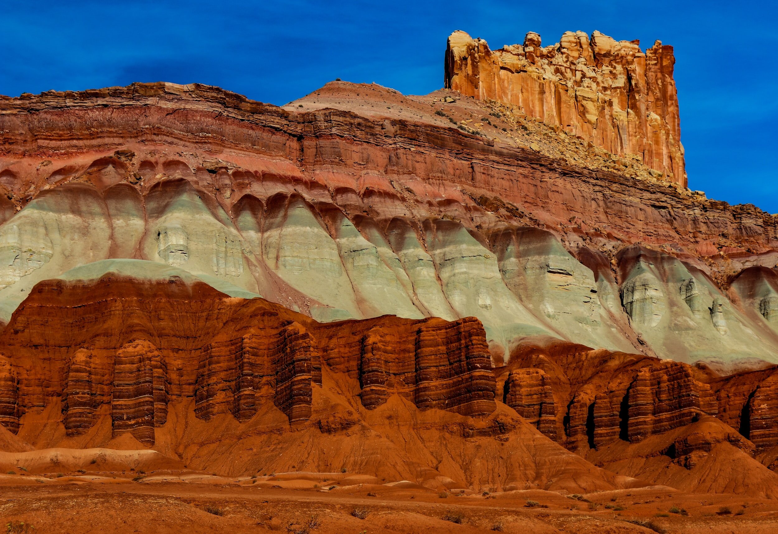
1. It is thin (<80 ft; mostly <40 ft) across most of the Denver Basin except in part of the central basin where it has been removed by erosion. Some would call its geometry “blanketlike."

2. Bioturbation is abundant and pervasive in most of the Codell, but decreases toward the northwest where both grain size and inferred current energy during deposition increase. 

3. Despite appearing poorly sorted, the Codell consists of homogenous very small grains that are well sorted and mostly of coarse silt to upper very fine sand size (40-100 microns).

4. The apparent poor sorting is due to a “textural inversion” created by bioturbation mixing up to 25% detrital clays, mainly illite-smectite & illite-mica, into the well-sorted silt and sand grains. 

5. The sand grains are mineralogically mature with quartz, chert, and some feldspars, but with few rock fragments other than chert and no unstable minerals (e.g., hornblende, augite). 

6. Its detrital zircon population is atypical with predominantly “young” 98-93 Ma zircon crystals derived from weathering of units such as the Arrow Creek, Clay Spur, “X,” and other bentonites.

7. It has an anomalously high phosphorous content compared to adjacent strata. The phosphorous is in abraded bone and teeth fragments suggesting a reworked marine vertebrate fauna.

8. Other than sparse oyster and Inoceramus shell fragments, the Codell is remarkably free of calcareous fossils, particularly intact ones, when compared with the adjacent intervals. This complicates its biostratigraphic dating and documenting the duration of its deposition, which we believe to be quite short, probably less than 0.2 Ma (<than the P. hyatti ammonite zone).

Conclusion: The Codell is a reworked shallow marine shelf deposit covering >100,000 mi2.


ML Pic.JPG

Mark received a B.A. degree from Albion College in Michigan in 1972 followed by a Ph.D. in Geology from the University of Texas at Austin in 1976. He then joined the research lab of Cities Service Company in Tulsa, Oklahoma for 5 years before moving to Denver in 1981 to work for Coastal Oil and Gas Company as an exploration geologist mainly in the Williston Basin. From 1984 to 2006, he was a consulting geologist before joining QEP Resources, where he worked as their “Rock Expert” until 2018 when QEP restructured and no longer needed his skills as a sedimentologist and petrographer. Mark enjoys looking at cores, cuttings, and petrographic thin sections with a focus on integrating sedimentology and petrology with reservoir studies and petrophysics. He has worked extensively on the Cretaceous rocks and reservoirs in the Rocky Mountain region.

Mark is currently a Research Associate at the Denver Museum of Nature and Science and a part-time consulting geologist. He has published more than 40 papers in journals ranging from RMAG’s The Mountain Geologist to the AAPG Bulletin and in 2014 co-edited AAPG Memoir 107 on Pinedale Field. In 2016 he received AAPG’s Distinguished Service Award.

Click the Dunes to Register Now!

Webinars are free to attend

Please submit reservations by 10:00 a.m (MT) the day before the talk.

Email questions to information@rmssepm.org

View Event →
Webinar: October 27th-Kathryn Schuller
Oct
27
12:00 PM12:00

Webinar: October 27th-Kathryn Schuller

Using Public Sources to Compile Geologic Data and Analyze Petroleum Reservoirs

Presented by:

Kathryn Schuller


Discussion Starts at 12:00 (MT)
Webinar


Abstract

Public data is widely available, easier than ever to access, and can be a vital tool when analyzing oil and gas fields on a broad scale. Everything from well logs, core data, stratigraphic tops, petrophysical properties, to shape files, basic well data, key descriptive figures, and reservoir properties can often be found online. Using the Uintah Basin in northern Utah as a case study, we will be discussing the various sources, methods, and pitfalls when searching for and using public data, along with how it can be a valuable resource for every project.

Join us for a presentation and discussion….


Kathryn was born and raised in Colorado and credits this for her love of the mountains and rock hunting from a young age. She earned a BA in Petroleum Geology from Western State in Gunnison, Colorado, and a MS in Geology from Colorado State Universi…

Kathryn was born and raised in Colorado and credits this for her love of the mountains and rock hunting from a young age. She earned a BA in Petroleum Geology from Western State in Gunnison, Colorado, and a MS in Geology from Colorado State University in Fort Collins, Colorado. Her thesis work focused on the cyclic deposition of carbonates and siliciclastic mudstone (shales) facies on the Scandinavian deep shelf near Oslo, Norway. Between her BA and MS, she worked for three years at Anadarko Petroleum Corporation in the Greater Natural Buttes field in Utah. She currently works as a geoscientist at MI3 Petroleum Engineering in Golden, Colorado providing geologic support to create 3D subsurface reservoir models for fields across the US. She loves skiing, collecting fossils, and boring fellow hikers about the local geology.

Click the Dunes to Register Now!

Webinars are free to attend

Please submit reservations by 10:00 a.m (MT) the day before the talk.

Email questions to information@rmssepm.org

View Event →
Webinar: September 29th-Rebekah E. Simon
Sep
29
12:00 PM12:00

Webinar: September 29th-Rebekah E. Simon

Investigating Heterogeneity of Migrated Petroleum at the Nano-scale in a Chalk Reservoir, Cretaceous Niobrara Formation, Denver Basin, CO

Presented by:

Rebekah E. Simon


Meeting Starts | 12:00 (MT)


Abstract

Low permeability unconventional oil and gas resources may experience formation damage due to the emplacement of viscous hydrocarbons in narrow pore throats during petroleum migration and production. The composition of such pore-clogging hydrocarbons remains under-characterized, as standard analytical techniques in organic geochemistry either lack the spatial resolution to collect chemically specific data in nano-pores, or require extraction and therefore averaging of the suite of compounds that make up bulk crude oil. Correlative imaging of oil-filled nano-pores in Niobrara chalk samples using two novel AFM based techniques—Infrared scattering-Scanning Near-field Optical Microscopy (IR s-SNOM), and Scanning Probe Microscopy—provide pixel maps of the chemical and mechanical properties of migrated oil with ~30 nm xy-resolution. These correlative images demonstrate that heterogeneity exists within emplaced hydrocarbons in situ on the scale of hundreds of nanometers, visualized as clusters of hydrocarbon having high adhesive forces and material rigidity. The chemical composition of these clusters remains ambiguous, but their geometry and mechanical properties may imply that they are phase-separated asphaltene preferentially associated with oil-attractive nano-domains on calcite pore walls. Despite outstanding challenges, correlative IR s-SNOM and nano-mechanical imaging offer a promising and novel analytical approach to understanding fluid behavior in nano-porous reservoir rocks and its effects on pore network evolution.


Rebekah (Becky) Simon is currently a geoscientist with ExxonMobil in Houston, TX. She received her Ph.D. from the University of Colorado (CU) Boulder in May of 2020 for her dissertation completed under the direction of Dr. David Budd. She holds a Master of Science in Geological Sciences from The University of Texas at Austin, and a Bachelor of Science in Geological Engineering from Colorado School of Mines. The work in this presentation was done in collaboration with members of the Center for Ultra-Fast Nano-Optics in the CU Boulder Department of Physics (Raschke, PI).


Click the Dunes to Register Now!

Webinars are free to attend

Please submit reservations by 10:00 a.m (MT) the day before the talk.

Email questions to information@rmssepm.org

View Event →
Webinar: September 1st
Sep
1
12:00 PM12:00

Webinar: September 1st

Fluvial Strata Preservation and Implications

A discussion led by:

RMS-SEPM President Ellen Wilcox

Does anyone miss talking geology with colleagues? Who has an interest in fluvial sedimentology and geomorphology? Hopefully you said yes and will join the RMS-SEPM for our first webinar event! We invite members to read the article linked below and join our webinar to discuss the preservation of fluvial strata and its implications. We look forward to having you and hearing your thoughts and opinions.

Link to article:   https://phys.org/news/2020-06-reveals-geographical-perplexing-fluvial-strata.html

11:45 Meeting Starts | 12:00 (MT) Discussion

Please register below; webinar link will be sent out to each registrant prior to the meeting.


Ellen earned a B.S. in Geology from SUNY (State University of New York) Oswego before moving west to pursue an M.S. in Geology from the University of Colorado, Boulder. Ellen is the newly elected President of the RMS-SEPM and credits much of her con…

Ellen earned a B.S. in Geology from SUNY (State University of New York) Oswego before moving west to pursue an M.S. in Geology from the University of Colorado, Boulder. Ellen is the newly elected President of the RMS-SEPM and credits much of her continued love of geology to her mentors and geologic community, many whom she met at RMS-SEPM luncheons. She offered to kick start the webinar series to help the community stay connected and engaged in sedimentary geology, especially during challenging and isolating times


Register Now

Webinars are free to attend

Please submit reservations by 10:00 a.m (MT) the day before the talk.

Email questions to information@rmssepm.org

View Event →